- OIL TANKER TRACKING
Oil Tanker Tracking System: How GPS Improves Fleet Visibility
Monitor tanker locations, routes, stops, geofence events, and trip history with GPS-based tracking designed for petroleum and oil transport fleets. Improve real-time visibility, streamline trip coordination, review vehicle activity, and make informed operational decisions with centralized fleet monitoring.
What Is an Oil Tanker Tracking System?
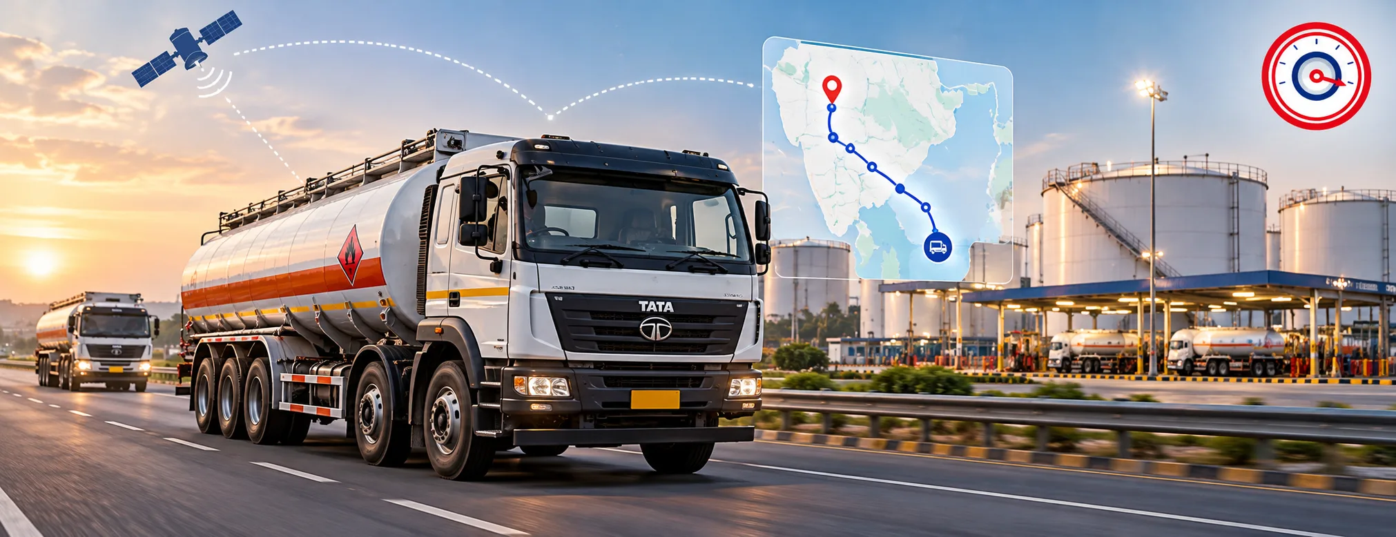
An oil tanker tracking system is a GPS-based vehicle monitoring solution used to track the location and movement of tanker trucks during transportation operations.
A compatible tracking device installed in the vehicle determines its position and sends selected data to a connected fleet platform. Fleet managers can then review tanker movement through maps, trip records, route history, stop information, geofence events, and configured alerts.
Depending on the hardware and system configuration, tanker fleets may be able to monitor:
- Live vehicle location
- Trip start and end
- Route history
- Stops and dwell time
- Geofence entry and exit
- Speed events
- Ignition status
- Vehicle movement history
- Selected driver events
- Operational alerts
India’s Ministry of Road Transport & Highways publishes the AIS-140 vehicle location tracking specification, which defines requirements for vehicle-location tracking devices and backend monitoring systems.
For broader commercial vehicle tracking capabilities, explore Diselmap’s GPS Tracking System.
Why Oil Tanker Fleets Need Better Vehicle Visibility
Tanker operations often involve planned movement between specific locations such as fuel depots, loading terminals, storage facilities, distribution points, and customer sites.
Without connected tracking, fleet information can become fragmented across driver calls, dispatch records, spreadsheets, gate entries, and manual trip updates.
GPS tracking gives fleet managers a more consistent way to answer important operational questions.
Where Is the Tanker Right Now?
Live vehicle tracking gives dispatchers a current view of tanker locations without requiring repeated calls to drivers.
This can be especially useful when several vehicles are operating across different routes or locations at the same time.
Is the Tanker Following the Expected Route?
Route history and trip data allow teams to review how a vehicle is moving compared with the expected journey.
A route difference does not automatically indicate misuse. Road conditions, traffic, diversions, site instructions, and other operational factors should always be considered.
Has the Tanker Stopped Unexpectedly?
Stop and dwell-time information can help identify long or unusual stationary periods.
Fleet teams can then review the location, duration, route, and trip context before deciding whether any follow-up is required.
Has the Vehicle Reached the Required Site?
Geofences can be configured around important operational locations such as depots, terminals, yards, and customer sites.
Entry and exit events provide useful trip milestones without requiring constant manual updates.
How GPS Tanker Tracking Works
GPS tanker tracking converts vehicle-location data into useful trip and operational information.
1. Capture Vehicle Location
A compatible GPS tracking device determines the tanker’s position during operation.
Depending on the device and installation, additional information such as ignition status, speed, or selected driving events may also be available.
2. Transmit Vehicle Data
The tracking device sends selected information to the connected fleet platform through an available communication network.
Authorized users can then access the information remotely.
3. Organize Data into Trips and Events
Raw location points become more useful when the platform organizes them into:
- Live location
- Routes
- Stops
- Trip history
- Geofence events
- Vehicle status
- Alerts
This converts location data into information that fleet teams can actually use.
4. Review and Act
Fleet managers and dispatch teams can review trip progress, identify unusual activity, investigate delays, and coordinate tanker movement using the available data.
The technology supports operational decisions; it does not replace human judgement or established fleet procedures.
Key Features of an Oil Tanker Tracking System
Real-Time Tanker Tracking
Live GPS tracking helps fleet managers monitor the current location, movement, and operating status of tanker vehicles.
A centralized map view can provide visibility across multiple vehicles without requiring individual location updates.
Route and Trip History
Historical tracking records allow teams to review where a tanker travelled and how a trip progressed.
Trip history may help fleet managers review:
- Completed routes
- Travel periods
- Stops
- Route deviations
- Trip duration
- Repeated journey patterns
Historical data can be particularly useful when reviewing an operational issue after the trip has ended.
Geofencing
A geofence is a virtual boundary created around a real-world location.
For oil tanker operations, geofences may be configured around:
- Fuel depots
- Loading terminals
- Storage facilities
- Distribution centres
- Customer sites
- Service yards
When a tracked vehicle enters or exits a configured area, the system can record the event or trigger a notification.
Stop and Dwell-Time Monitoring
Tankers may stop because of loading, unloading, traffic, driver breaks, route conditions, or operational requirements.
Monitoring stop duration helps fleet teams understand how long vehicles remain stationary at different locations.
The goal is not to classify every long stop as a problem. Fleet teams should review the full trip and operational context.
Speed and Driving Events
Compatible GPS and telematics systems may provide selected driving events such as:
- Overspeeding
- Harsh braking
- Rapid acceleration
- Sharp cornering
- Excessive idling
For deeper driver-performance analysis, use a dedicated solution such as Diselmap’s Driver Behavior Monitoring System.
Configurable Alerts
Alerts can help fleet teams respond to selected events without continuously watching every vehicle on a map.
Examples may include:
- Geofence entry or exit
- Overspeed events
- Extended stops
- Unexpected movement
- Ignition events
- Selected route exceptions
Alert thresholds should reflect actual operational requirements so fleet managers are not overwhelmed by unnecessary notifications.
Benefits of GPS Tracking for Tanker Fleets
Improve Tanker Visibility
Fleet teams can view where vehicles are operating and how individual journeys are progressing.
This reduces dependence on fragmented manual updates.
Improve Trip Coordination
Dispatch teams can make better-informed decisions when tanker locations and trip progress are visible from one platform.
Review Route Activity
Historical route information helps fleet managers compare actual journeys with planned movement and identify recurring exceptions.
Monitor Important Locations
Geofencing provides a structured way to record vehicle entry and exit around depots, terminals, and customer sites.
Investigate Exceptions Faster
If a tanker is delayed, stationary, or operating outside an expected area, location and trip history provide additional context for review.
Reduce Manual Location Checks
Routine questions such as “Where is the tanker?” may not always require a phone call when vehicle-location information is already available to the fleet team.
Practical Example: Depot-to-Customer Tanker Journey
Consider a tanker scheduled to travel from a petroleum depot to a customer location.
Depot Exit
The tanker leaves the configured depot geofence.
The fleet platform records the departure event and begins tracking the journey.
Highway Transit
The operations team reviews the tanker’s location and trip progress through the fleet dashboard.
Selected speed or vehicle events may also be recorded depending on the system configuration.
Unexpected Stop
The tanker remains stationary for longer than expected.
Fleet managers can review the stop location, duration, and trip context before contacting the driver or taking further action.
Customer Arrival
The vehicle enters the customer-site geofence.
This provides a location-based arrival record.
Return Journey
The platform continues recording the vehicle’s movement and trip history as it returns to the depot or proceeds to another assigned location.
It is important to remember that GPS confirms vehicle movement and location events. A geofence entry should not automatically be treated as proof that loading, unloading, or delivery was completed unless those activities are confirmed through the appropriate operational process or business system.
Challenges and Limitations of GPS Tanker Tracking
GPS tracking provides valuable visibility, but no system should be presented as perfect in every operating environment.
Network Connectivity
Vehicle information may depend on available communication coverage for data transmission.
Remote locations can sometimes affect how quickly information reaches the platform.
GPS Conditions
Location accuracy can be influenced by satellite visibility, surrounding structures, terrain, or operating conditions.
Hardware Installation
Device placement, power supply, configuration, and installation quality can influence tracking reliability.
Alert Configuration
Poorly configured thresholds may generate too many low-value alerts.
Fleet managers should prioritize events that genuinely require operational attention.
Data Interpretation
A long stop, route deviation, or overspeed event provides information—not an automatic conclusion.
Fleet teams should review the operational context before classifying an event as misuse, non-compliance, or another issue.
GPS Tanker Tracking vs Fuel Monitoring
GPS tracking and fuel monitoring support different operational requirements.
| Area | GPS Tanker Tracking | Fuel Monitoring |
|---|---|---|
| Primary purpose | Vehicle and trip visibility | Fuel activity visibility |
| Live vehicle location | Yes | Not the primary function |
| Route history | Yes | No |
| Geofencing | Yes | No |
| Stops and trips | Yes | No |
| Fuel level | Not directly | With compatible sensor |
| Refuelling activity | Not directly | Can be monitored |
| Abnormal fuel drops | Not directly | Can be investigated |
| Best suited for | Trip and vehicle monitoring | Fuel analysis and control |
A simple way to understand the difference is:
GPS tracking tells you where the tanker is. Fuel monitoring helps you understand what is happening with the fuel data.
For detailed fuel functionality, see Diselmap’s Fuel Management System and Fuel Level Sensor.
How Tanker Tracking Fits into Oil & Gas Fleet Management
Oil tanker tracking is one part of a broader connected fleet operation.
Oil and gas fleet management may combine:
- GPS tracking
- Vehicle telematics
- Fuel monitoring
- Driver behaviour monitoring
- Dashcam and video monitoring
- Vehicle diagnostics
- Maintenance information
- Remote asset tracking
The tracking layer primarily provides vehicle and trip visibility.
Other technologies provide additional information about fuel, drivers, vehicle condition, safety, or asset usage.
For a broader industry-level solution, explore Diselmap’s Oil & Gas Fleet Management Solutions.
How to Choose the Right Oil Tanker Tracking System
The best system depends on the fleet’s routes, operating environment, vehicle types, reporting needs, and existing technology.
Reliable Location Tracking
Choose a system that provides usable location and trip information across your normal operating routes.
Geofencing
If operations involve fixed depots, terminals, or customer sites, geofencing can provide valuable operational context.
Historical Trip Records
Fleet managers should be able to review previous journeys, routes, stops, and selected vehicle events.
Useful Alerts
Alerts should be configurable around meaningful business requirements rather than generating constant unnecessary notifications.
Centralized Dashboard
A fleet-wide platform should allow managers to review multiple tanker vehicles from a single interface.
Reporting
Historical reports should make it possible to analyse vehicle activity over selected time periods.
Integration Capabilities
Consider whether the tanker tracking system needs to work with:
- Vehicle telematics
- Driver monitoring
- Fuel monitoring
- CAN Bus systems
- Fleet management software
Installation and Support
Hardware selection is only one part of deployment.
Installation, system configuration, onboarding, and ongoing technical support also influence long-term system reliability.
Regulatory Context for Petroleum Tankers in India
Petroleum transportation operates within a regulated environment in India.
The Petroleum and Explosives Safety Organisation (PESO) administers regulations and licensing requirements related to petroleum storage, transportation, and associated equipment.
Fleet operators transporting petroleum by road should refer to the applicable Petroleum Rules, 2002 and current guidance from relevant authorities.
GPS tracking should be treated as an operational visibility tool. It does not replace vehicle licensing, driver requirements, tanker construction standards, transport rules, or other legal and safety obligations.
Requirements can vary according to the vehicle, petroleum category, operating activity, and applicable regulation, so businesses should confirm current requirements through the relevant government authority.
Common Mistakes When Using Tanker GPS Tracking
Treating Every Route Deviation as Misuse
Traffic, road closures, diversions, access restrictions, and operating instructions can all change a vehicle’s route.
Always review context first.
Creating Too Many Alerts
Too many notifications can make important fleet events harder to identify.
Focus on meaningful operational thresholds.
Monitoring Only Real-Time Location
Live tracking is useful, but historical patterns across routes, trips, stops, and vehicles can provide deeper operational insight.
Assuming GPS Tracks Fuel
GPS tracking primarily provides vehicle-location and movement information.
Fuel-level monitoring requires compatible fuel-monitoring equipment.
Assuming Tracking Replaces Compliance
GPS tracking can improve operational visibility, but it does not replace applicable petroleum transport, vehicle, safety, or licensing requirements.
Frequently Asked Questions About Oil Tanker Tracking
What is an oil tanker tracking system?
An oil tanker tracking system uses GPS and connected fleet technology to monitor tanker location, movement, routes, stops, trip history, and selected vehicle events from a centralized platform.
Can oil tankers be tracked in real time?
Compatible GPS tracking systems can provide frequently updated location information when the tracking hardware, satellite positioning, and communication network are available.
What information can tanker fleet managers monitor?
Depending on system configuration, fleet managers may review live location, route history, trips, stops, geofence events, ignition status, speed, and selected operational alerts.
What is geofencing in tanker tracking?
Geofencing creates a virtual boundary around a real-world location such as a depot, terminal, or customer site. The platform can record selected events when a tracked tanker enters or leaves that area.
Can GPS tracking detect fuel theft?
GPS tracking alone primarily provides vehicle location and movement information. Fuel-level changes generally require compatible fuel-monitoring hardware. GPS location data can provide additional context when investigating a fuel-related event.
Is tanker tracking the same as fleet management?
No. Tanker tracking focuses primarily on vehicle location, routes, trips, stops, and related events. Fleet management is broader and may include maintenance, fuel management, driver performance, vehicle diagnostics, and operational reporting.
Can tanker tracking monitor driver behaviour?
Compatible GPS and telematics systems can provide selected driving events such as speeding, harsh braking, acceleration, cornering, or idling. More detailed driver monitoring may require additional telematics or camera-based systems.
Conclusion
An oil tanker tracking system provides more value than simply displaying a vehicle on a map.By combining live location, trip history, routes, stops, geofence events, and configured alerts, fleet operators can build a clearer picture of tanker movement and trip progress.
The purpose is not to replace dispatchers, drivers, or established operating procedures. It is to give fleet teams better information for monitoring vehicles, reviewing exceptions, and coordinating transportation activities.For oil and gas businesses operating tanker fleets, service vehicles, and remote assets, GPS tracking can also become an important part of a broader connected fleet-management strategy.
Improve Tanker Fleet Visibility with Diselmap
Diselmap helps businesses monitor oil tankers and commercial fleet vehicles using connected GPS tracking, telematics, and fleet-management technology.
Track vehicle locations, routes, trips, stops, geofence activity, and operational history through a centralized platform configured around your fleet requirements.